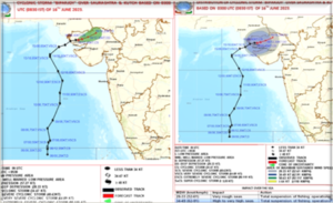
IMD prediction over movement of Cyclone Biporjoy

What exactly is Cyclone Biparjoy?
In Bengali, the word ‘Biparjoy’ maybe translated to literally mean calamity. The occurrence coined after the word and so considered to be calamity brought down upon earth is the Cyclone Biparjoy. Cyclone Biparjoy is a tropical and extremely severe cyclonic storm that formed over the East-Central Arabian Sea.

Cyclone Biparjoy originated from a depression which was first noted by the India Meteorological Department (IMD) and then accelerated north-eastward, transforming into the equivalent of a Category-3 tropical storm. Biparjoy is the second cyclonic storm and the third depression of the ‘2023 North Indian Ocean Cyclone season.’
Biparjoy and IMD

At a speed of thirteen kilometers per hour in the last six hours moved north-eastwards over Saurashtra and Kutch with the cyclone lying centered at about eighty kilometers north-northeast of Bhuj and about twenty kilometers west of Dholavira. According to the information from the Indian Meteorological Department (IMD) Biparjoy is likely to move further northeastwards over Saurashtra and Kutch and weaken into a deep depression soon enough. IMD issued the following predictions/warnings and suggestion in relation to Cyclone Biparjoy:
- The speed of prevailing Gale winds over Kutch, Gulf of Kutch and several adjoining areas were nearing seventy to eighty kilometers per hour and gusting as high as ninety kilometers per hour.
- Light to moderate rainfall over South Rajasthan and Suarashtra North Gujarat region.
- Red alert for heavy to extreme rainfall over Badmer and Jalore districts of Rajasthan and some areas of Kutch, Patan and Banaskantha districts of Gujarat.
- Orange alert issued for Pali, Jodhpur, Sirohi and six other districts.
- The IMD has also warned against pursuing fishing activities over northeast and adjoining east-central Arabian Sea and urges implementation and strict observation of judicious regulations for onshore and off-shore activities.
Impacts of Tropical Cyclones

Tropical cyclones may potentially cause great damages and pose grave dangers as well as they bring with them heavy rainfall, extremely strong winds, surge of water causing flooding and damages, storm surges causing inundation of low-lying coastal areas.
1) Wind – The eye of the cyclone or rather the center of a cyclone is circled by spiraling gusts of wind traveling at the excess speed of ninety kilometers per hour, known as ‘Gale force winds.’ These gale force winds can exceed the speed of over two hundred and eighty kilometers per hour as far as the more severe cyclones are considered.
The grave threat posed by these cyclonic winds are the extensive damages caused by them as well as the dangerous force with which it sends air-borne debris hurtling with. In fact, the debris sent hurtling so at a great force by the cyclonic winds could be potentially as dangerous and lethal as an inbound missile.
An important characteristic of cyclonic winds, is that an area over which the eye (center) of the cyclone passes over experiences a sudden lull in the atmospheric winds which then suddenly changes and is substituted with winds of extremely high pressure from another direction.
2) Rain – One of the major after effects of a cyclonic storm is the extensive flooding that follows due to the extreme and heavy rainfall. As a cyclone moves inland and the pressure begins to weaken over time transforming into a low-pressure system, heavy rainfall may persist which means that flooding and rainfall can occur at quite a distance from where the cyclone actually made landfall.
3) Storm Surge – Due to the reduction in atmospheric pressure and the strong onshore winds the sea rises well above the highest tides on a normal day. This phenomenon is known as storm surges, as the sea surges above usual heights as a result of the tropical cyclone. The Storm Surge is by far the most dangerous of all the impacts associated with a cyclonic storm.


